


For Those Inquiring About Zoning and Related Areas
- Viewing of Urban Planning Maps for Zoning Areas
- About Urban Planning Facilities
- Latest Changes in Zoning and Related Urban Planning
- Internet Provision Service for Urban Planning Information by the Tokyo Metropolitan Bureau of Urban Development
- About Height Restrictions in Inagi City
- Inagi City Related Agencies Contact
Viewing of Urban Planning Maps for Zoning Areas
Notes on Using the City Planning Map
This city planning map is current as of March 2026.
Inagi City does not guarantee the complete accuracy of this map information or that it will function properly on all users' computers. Furthermore, we accept no responsibility for any damages that may arise from this. Copyright for information such as topographic maps and urban planning maps belongs to Tokyo Metropolis and Inagi City. Please proceed below only if you agree.
-
【1】Inagi City Urban Planning Map (Map Sheet) (PDF 4.7 MB)

-
【2】Inagi City Urban Planning Map (Overview Sheet) (PDF 4.5 MB)
If you would like to print the enlarged image, please use the print screen function or similar to capture the image and print it.
If you are inquiring by phone, please provide the name of the location, lot number, or address (if it is within a land readjustment area, please provide the provisional transfer number).
About Urban Planning Facilities
For urban planning facilities including production green areas, please refer to the "Inagi City Urban Planning Facility Map and Inagi City Production Green Area Map."
About Urban Planning Roads
For urban planning roads, please refer to the "Inagi City Urban Planning Road Network Map."
Latest Changes in Zoning and Related Urban Planning
Change in Enokido District (Notified on November 28, 2025)
-
Tama Urban Planning Road No. 7-5-2 Park Street Nashi-no-Michi Line Planning Map (PDF 1.1 MB)
-
Tama Urban Planning Park No. 2-2-14 Yanokuchi Park Planning Map (PDF 1.1 MB)
-
Enokido District Plan Map (Zoning, etc.) (PDF 1.2 MB)
- Inagi Enokido District Plan
Internet Provision Service for Urban Planning Information by the Tokyo Metropolitan Bureau of Urban Development
You can also use the link below to search by the place name or address you are looking for.
[Notice]District Plan Document must be downloaded from the Inagi City website "List of District Plan Locations and Planning Documents." Additionally, the "Recent Changes to Land Use Areas and Other Urban Planning" below are not reflected in the Tokyo Metropolitan Government's urban planning information internet service.
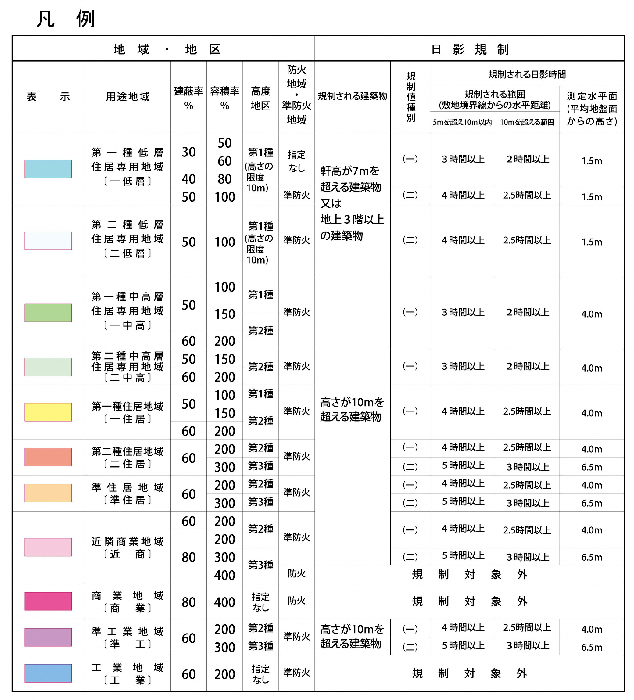
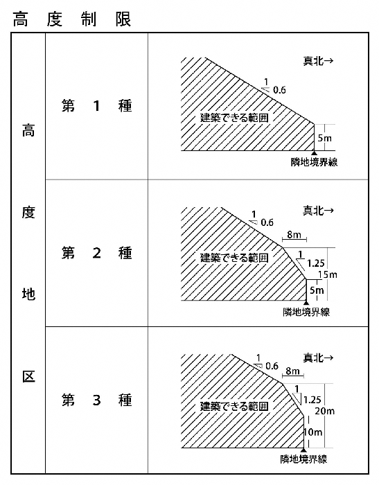
About Height Restrictions in Inagi City
Please check the types of height districts from the legend of the Inagi City Urban Planning Map.
The height restrictions by type are as shown in the figure below. For more detailed restrictions, please refer to the Inagi City Urban Planning Map (Overview).
- There are districts that set maximum height limits for buildings and structures in the District Plan. For details, please check the location of the District Plan and the list of planning documents.
・For construction projects of mid- to high-rise buildings where the building height exceeds 10 meters, these fall under the scope of the Guidelines for Residential Land Development in Inagi City. Please refer to the Guidance on the Maximum Height Limits for Mid- to High-Rise Buildings Constructed in Inagi City regarding the maximum height limits.
・For restrictions such as northern side, road, and adjacent land diagonal line limits under the Building Standards Act, please contact the Tama Building Guidance Office, Tokyo.
Inagi City Related Agencies Contact
For consultations regarding building confirmation applications and guidance on the Building Standards Act, please contact the Tokyo Tama Building Guidance Office. For other inquiries, please refer to the list of related organizations in Inagi City above (for reference).
To view the PDF file, you need "Adobe(R) Reader(R)". If you do not have it, please download it for free from Adobe website (new window).
This page is managed by the Community Development Planning Division, Department of Urban Development
2111 Higashi-Naganuma, Inagi City, Tokyo 206-8601
Phone number: 042-378-2111 Fax number: 042-378-9719
Contact the Community Development Planning Division, Department of Urban Development, Inagi City