


What is the Address Organization Project?
The current method of displaying addresses and locations in Inagi City uses the land number, known as the lot number.
The land number was originally established not to identify people's places of residence, but was primarily assigned to land for tax purposes during the Meiji era.
As a result, every time land subdivision or road maintenance is carried out, the regularity of the numbering is lost, leading to a confusing situation where numbers are skipped and multiple houses are built on the same lot number.
To resolve such situations, we are working on organizing clear displays of addresses and locations.
Effects of Address Organization
Address organization, along with the review of town areas and the establishment of blocks, can improve the convenience and safety of citizens' lives by organizing the display of addresses and locations. Additionally, it allows for the understanding of the number of households in each town area, which can lead to improvements in community activities and also has expected effects on responses during disasters.
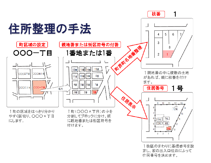
Address Organization Methods
There are two methods for address organization: "Town Boundary and Town Name Numbering Organization" which renumbers land parcels, and "Residential Addressing" which assigns addresses based on the location of buildings.
Current Situation of Inagi City
Inagi City was established in Meiji 22 when six villages, Yanokuchi, Higashi-Naganuma, Omaru, Momura, Sakahama, and Hirao, merged to form Inagi Village. Later, in Showa 24, the Oshitate District was incorporated, and with the increase in population, it became Inagi Town in Showa 32 and Inagi City in Showa 46. With the progress of the Tama New Town project, the Koyodai District, Nagamine District, and Wakabadai District were established, and together with the previous seven districts, it is now composed of ten districts.
Regarding the organization of addresses, town boundary and name numbering were implemented in the Koyodai District in 1987, in the Nagamine District in 1994, and in the Wakabadai District in 1998, in line with the opening of the Tama New Town area. Additionally, in the existing urban area, town boundary and name numbering were carried out in parts of the Hirao District in 1990 and 1993.
District List
Total: 1,797.0 hectares
| District Name | Town Name | Small Character Count | Area (hectares) |
|---|---|---|---|
|
Yanokuchi |
- |
17 characters |
256.6 |
|
Higashi-Naganuma |
- |
17 characters |
193.4 |
|
Omaru |
- |
27 characters |
318.8 |
|
Momura |
- |
16 characters |
130 |
|
Sakahama |
- |
39 characters |
372.5 |
|
Oshitate |
- |
6 characters |
82.9 |
Hirao District
| District Name | Town Name | Small Character Count | Area (hectares) |
|---|---|---|---|
|
- |
Hirao 1-chome |
|
38.7 |
|
- |
Hirao 2-chome |
|
39.5 |
|
- |
Hirao 3-chome |
|
34.4 |
|
- |
Hirao 4-chome |
|
37.6 |
Hirao subtotal: 150.2 hectares
Notes
July 1, 1990 - Change of Town Boundary, Town Name, and Lot Number (Establishment of Blocks 1 to 3)
November 15, 1993 - Change of Town Boundary, Town Name, and Lot Number (Part of 2-chome)
March 2, 2019 - Change of Town Name and Lot Number (New Establishment of 4th District)
Koyodai District
| District Name | Town Name | Small Character Count | Area (hectares) |
|---|---|---|---|
|
- |
Koyodai 1-chome |
|
6.7 |
|
- |
Koyodai 2-chome |
|
7.9 |
|
- |
Koyodai 3-chome |
|
15.9 |
|
- |
Koyodai 4-chome |
|
30.9 |
|
- |
Koyodai 5-chome |
|
7.4 |
|
- |
Koyodai 6-chome |
|
25.2 |
Koyodai subtotal: 94 hectares
Notes
July 1, 1987 - Establishment of Town Area
Nagamine District
| District Name | Town Name | Small Character Count | Area (hectares) |
|---|---|---|---|
|
|
Nagamine 1-chome |
|
22 |
|
|
Nagamine 2-chome |
|
16.4 |
|
|
Nagamine 3-chome |
|
28.4 |
Nagamine Subtotal: 66.8 hectares
Notes
October 1, 1994 - Establishment of Town Area
Wakabadai Area
| District Name | Town Name | Small Character Count | Area (hectares) |
|---|---|---|---|
|
|
Wakabadai 1-chome |
|
49.1 |
|
|
Wakabadai 2-chome |
|
25.3 |
|
|
Wakabadai 3-chome |
|
28 |
|
|
Wakabadai 4-chome |
|
29.4 |
Wakabadai Subtotal: 131.8 hectares
Notes
October 1, 1998 - Establishment of Town Area
To view the PDF file, you need "Adobe(R) Reader(R)". If you do not have it, please download it for free from Adobe website (new window).
This page is managed by the Department of Urban Development Community Development Revitalization Division
2111 Higashi-Naganuma, Inagi City, Tokyo 206-8601
Phone number: 042-378-2111 Fax number: 042-378-9719
Contact Us for Community Development Revitalization Section, Department of Urban Development, Inagi City