


iBus Route Map, Timetable, and Transfer Information at Major Bus Stops
The iBus, Inagi City's community bus, has been operating its third revised route since April 1, 2026. Please see below for the route map and timetable related to this route.
Additionally, the "iBus Route Map and Timetable" is distributed at Inagi City Hall (General Information Desk, Management Section Desk, etc.), Hirao Branch Office, Wakabadai Branch Office, Inagi City Hospital, each Cultural Center, Friend Hirao, Central Library, Inagi Transmission Base Pair Terrace, Community Promotion Plaza, Comprehensive Gymnasium, and other locations.
iBus Route Map (Overall)

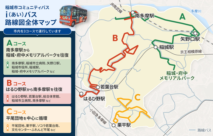
Course A Minami-Tama Station ⇔ Inagi / Fuchu Memorial Park Route 【Minami Kanko Kotsu Co., Ltd.】
This route runs back and forth between Minami-Tama Station and Inagi-Fuchu Memorial Park. It stops at Inagi City Hospital, Fourth Cultural Center Entrance, Yanokuchi Station, Inagi City Hall, Inagi Station, Minamiyama, and others.

Course B Haruhino Station ⇔ Minami-Tama Station Route 【Odakyu Bus Co., Ltd.】
This route runs back and forth between Haruhino Station and Minami-Tama Station. It stops at Wakabadai Station, Nagamine, Comprehensive Gymnasium, Koyodai, Shiroyama Park, Inagi City Hospital, and others.

Course C Hirao Circular Route [Odakyu Bus Co., Ltd.]
This route circulates clockwise around Hirao. It stops at Hirao Housing Complex, Kurihira Station, Kamihirao, SOCOLA Wakabadai South, Cultural Center, Friend Hirao, and others.

Transfer Information at Major Bus Stops


To view the PDF file, you need "Adobe(R) Reader(R)". If you do not have it, please download it for free from Adobe website (new window).
This page is managed by the Management Division, Department of Urban Development
2111 Higashi-Naganuma, Inagi City, Tokyo 206-8601
Phone number: 042-378-2111 Fax number: 042-377-4781
Contact the Management Division, Department of Urban Development, Inagi City